Virtual Reality Point Cloud Scanning Technology
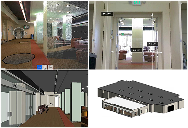
Schnackel Engineers offers virtual reality capture surveys for your projects utilizing full color point cloud scans integrated with hi-resolution panoramic photographs utilizing the Leica imaging laser scanner system and software.
The scanning process takes a full 360 degree point cloud scan including a complete 360 degree photographic image at each location scanned. Once the scanning is completed for the project it can be provided to you in raw data format or as a fully compiled project. The compiled project can be viewed in Leica TruView allowing you to virtually walk the site from scan location to scan location, zooming in or out and pulling physical dimensions as needed from any element in the point cloud model.
The raw point cloud data can be provided for direct use in Revit, or Schnackel Engineers can produce complete AutoCAD 2D/3D or Revit models from the point cloud information at varying levels of detail based on your specific needs. The addition of thermal imaging allows for proactive identification of potential issues, whether in equipment performance or envelope efficiency, so corrective measures can be taken before more serious problems arise.
Reality capture can be used to gather the existing conditions of your facility to be used in the architectural, structural, mechanical, electrical, plumbing and fire protection design of your project, as well as for construction observations and as-built documentation throughout the construction process. You will have a digital model of your project at various stages of construction that can be used to locate systems that would normally be concealed once construction is complete.
Virtual Reality Point Cloud Technology Scanning Services include:
- Full-color point cloud with integrated hi-resolution panoramic photos
- Revit/Autocad compatible output
- Digital twin of existing structures
- Virtual reality walk-through